Utilities have been using Geographic Information Systems (GIS) for decades. It has served utilities well, mapping the location of equipment, creating digital maps and collecting information from the field.
While GIS-produced maps are critical, utilities require more advanced network modeling. Alongside advanced data modeling, utilities need improved tools for data accuracy. GIS cannot exist in isolation; it must seamlessly integrate with other corporate systems such as Advanced Distribution Management Systems (ADMS), Supervisory Control and Data Acquisition (SCADA), customer information, asset and work management systems. Since location is crucial to a utility’s operations, GIS must be fully integrated into the corporate IT framework. Finally, GIS should offer a precise network model encompassing the latest network systems and components.
Consequently, Esri rebuilt its GIS technology, the ArcGIS system, to address the needs of the emerging utility business. This vision supports the notion of a smarter utility that is responsive to the challenges and opportunities of a fully connected utility network. It recognizes the changing patterns of energy production, use and delivery. Embedded in the ArcGIS system is a capability dubbed the ArcGIS Utility Network. In conjunction with many of the other GIS capabilities, such as spatial analysis, image management, integration with AI and machine learning, specific network capabilities include:
- Modeling
- Interoperability
- Enterprise access and collaboration
- Data quality and data governance
The ArcGIS Utility Network capability is not just a map-making tool or asset management tool. It is a comprehensive model that integrates all aspects of a utility, from the connected network that spans from generation to transmission to distribution systems to the end customers.
Why location matters
Customers, crews, assets and buildings are scattered throughout the utility service territory.
Understanding assets’ vulnerability is paramount. For instance, it is crucial to fully understand the optimal location for staging crews and equipment before an impending hurricane. Questions such as where to reinforce the network, identify at-risk vulnerable populations, or prioritize recovery efforts must be answered. Utilities must always be aware of current events and locations.
GIS provides the necessary location intelligence. Situations change rapidly, and GIS analysis can assist workers in adapting at a moment’s notice. The capability to convert data into valuable information is crucial for coordination, navigation, data collection and asset monitoring.
Modeling
For much of its history, GIS has been used to improve productivity by creating network maps faster and of higher quality. It wasn’t until utilities realized the digital map contained a network model buried within the graphic representation that they began to understand GIS was more than a map-making machine but a decision support system.
Furthermore, the focus on the digital map was to replicate the old paper maps exactly. The location of labels and attributes had to be placed in the same position as their former paper counterparts. Despite the digital nature of the maps, end users still printed maps with large-scale plotters. Hanging blueprints of the old paper maps on conference room walls were replaced by hanging plotted maps on the same walls. Despite digitization, the processes remained essentially unchanged. However, savvy users recognized that a digital representation of a gas or electric network could be helpful for various purposes, such as network analysis, engineering and design and customer connection workflows.
Nevertheless, the original data migration processes primarily focused on the appearance of the maps and not on the network representation. Fortunately, utilities have improved their GIS over the years to capture the connection between the networks. In the past, precision and modeling were relatively primitive due to the software’s limitations.
The ArcGIS Utility Network removed historic GIS limitations, allowing utility networks, including new network technologies such as phasor measurement units (PMUs), inverter-based resources and grid-enhancing technologies, to be precisely modeled within the GIS.
FirstEnergy, a large electric utility company operating in five states, faced the challenge of modernizing its network’s geospatial model. It implemented a solution that integrated GIS with ADMS, distribution automation and mobile graphic design within the Utility Network. This solution included enhancements such as internal substations, mesh networks, duct systems, and capabilities for analytics, capacity planning and load management. As a result, FirstEnergy achieved a high-accuracy foundation for all operational technology, allowing near real-time updates to ADMS, benefiting 650 employees and significantly improving network management and efficiency. Read the complete story.

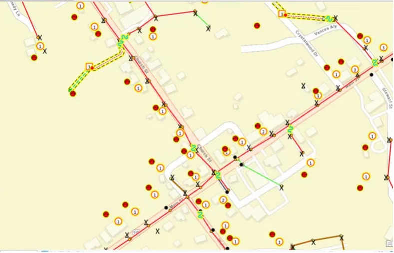
This screenshot shows FirstEnergy utilizes SSP Productivity and ArcGIS Pro to update network management data.
ArcGIS Utility Network transformed GIS from a mapping-only representation to a mapping and model representation.
ArcGIS provides robust network management capabilities that address the needs of today’s modernizing utilities. ArcGIS offers data models for electric, gas, telecommunications, water and district energy networks. It also models structures such as duct banks, conduits, trenches and poles shared by multiple domain networks, like electric utility and telecommunications networks.
Interoperability
Establishing a shared services platform across enterprise systems, including Enterprise Resource Planning (ERP), GIS and ADMS, can simplify asset management, streamline design, improve customer engagement and offer a holistic view of operations. This modern transparency of enterprise-wide data and intuitive dashboards enables improved asset performance, monitoring, design, planning and coordinated operations supported by real-time office and field decision-making.
The ArcGIS Utility Network adds to the business value of the core utility operational and business systems. The GIS brings additional context, such as weather, traffic and demographics. A modern digital utility requires harmonizing all these enterprise systems to achieve optimal performance and business value.
ESO, Lithuania’s energy distribution operator, faced challenges with its outdated legacy GIS. To enhance interoperability, they replaced it with the ArcGIS Utility Network and Similix’s CIM Adaptor to integrate with their ADMS, ensuring data integrity and ease of maintenance. This solution provided compatibility with industry-standard systems via the Common Information Model (CIM).
Lithuania’s Energy Distribution System Operator (ESO) has long leveraged Esri GIS technology to ensure the continuity of their electric operations.
The integration streamlined workflows eliminated redundant steps and allowed over 600 employees to access and update designs efficiently, ensuring accurate data integrity and improved operational performance across the network. Read the complete story.
The harmony of ERP and GIS serves as an example. The ERP and GIS are Information Technology (IT) systems that have worked in parallel for many years. The ERP manages the transactions of many essential utility workflows, including work execution, asset management plans, customer information and financial reporting. However, the ERP does not manage all asset types and groups. The ERP system oversees tracked assets throughout their maintenance lifecycle. The GIS manages the relationships of the asset attributes to their surroundings. The GIS links the asset data with other operational data and analytics to optimize CAPEX and OPEX programs of work. It collaborates with ERP systems to streamline engineering, design, asset management and workflow management.
The harmonization of ADMS and GIS is another example of how GIS provides insight and context. The integration offers a detailed understanding and visualization of the relationship between dispatch operations, customers and field mobility.
Enterprise access and collaboration
ArcGIS provides secure, pervasive user access to network information and data sharing across organizations and stakeholders. It uses an identity-based security model, granting specific permissions to manage data quality and protect against unauthorized access. Self-service portals offer access to data on any device without recreating content. The ArcGIS identity and sharing model helps control access, reduce risk and maintain security. ArcGIS supports a comprehensive view of business operations, enhancing executives’ and field workers’ situational awareness.
As a leader in the European region, Lyse Elnett recognized the potential of ArcGIS Utility Network. In 2017, Lyse, alongside other European utilities, formed the Utility Network Community (UNC) to define an open-source data model aligned with the Common Information Model (CIM). Partnering with Similix, Lyse implemented ArcGIS Utility Network for its electric distribution grid, taking a phased approach. This technology enhances data quality and integration, supporting a sustainable future. The project aims to provide comprehensive asset information and advanced analytics, benefiting various energy sectors, including district heating and cooling. Read the complete story.
The seamless integration of ArcGIS Utility Network with web-based and mobility applications allows engineers, customer designers and field crews to become more productive. They receive near real-time information as they work. The ArcGIS Utility Network provides access and a deep engagement framework throughout the utility enterprise from the board room to the utility vehicle dashboard.
Improved data quality and governance
The ArcGIS Utility Network uses network rules, attribute rules and validation to ensure data quality by preventing invalid data and associations from entering the network. For example, suppose a model specifies that a specific type of pipe can only connect to another type of pipe in combination with a reducer. In that case, only those configurations will be allowed. These rules are enforced for specific asset types and groups.
The Utility Network also includes advanced topology rules that can provide quality control “on the fly” by modeling how system components connect to terminal devices, such as transformers.
Louisville Gas and Electric Company (LG&E) and Kentucky Utilities Company (KU), serving over 1.3 million customers in Kentucky and Virginia, needed better data for design, smart grid and fieldwork. They replaced their legacy GIS with the ArcGIS Utility Network to improve data quality, latency and governance. This transition enabled efficient Automated Utility Design and provided rich field apps, enhancing design workflows and data access. As a result, LG&E and KU achieved more accurate and efficient design processes, saving time and improving overall operational efficiency. Read the complete story.
LG&E and KU’s crew are ready to begin the day
Editing rules and validation in the network ensure data quality by preventing the entry of logically invalid data and associations. The ArcGIS Utility Network capability provides a mechanism to detect logically inconsistent object associations. This is done by a user-defined network rule base specifying which object type can be connected and associated with another. For example, a medium-voltage transformer cannot be connected to a high-voltage line.
GIS shapes modern network management
ArcGIS is designed to model, manage, visualize and analyze modern networks in a changing landscape. It accommodates new kinds of network assets and connectivity rules. Hence, organizations are better positioned to solve business challenges arising from emerging industry pressures and shifting consumer expectations. Read the stories of peer utilities that have done just that.
ArcGIS supports modern technology patterns, enabling organizations to work and deliver information as expected by staff and external stakeholders. This entails accessing and editing data in the office and the field and sharing key information internally and externally—all within a secure environment that enables organizations to safeguard their data. Learn more.


